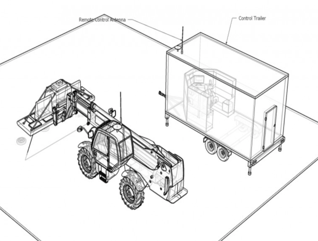
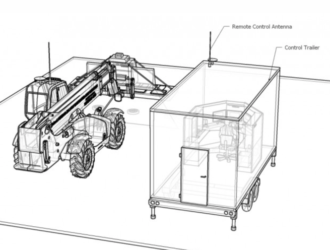
X-Ray Backscatter Landmine Tank Mine Detection
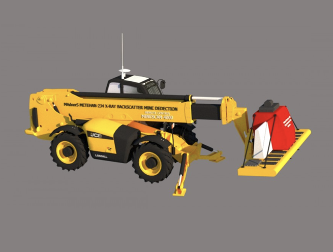
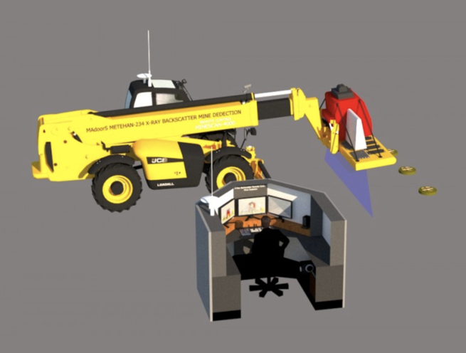
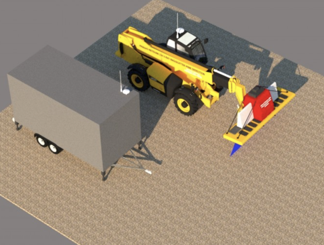
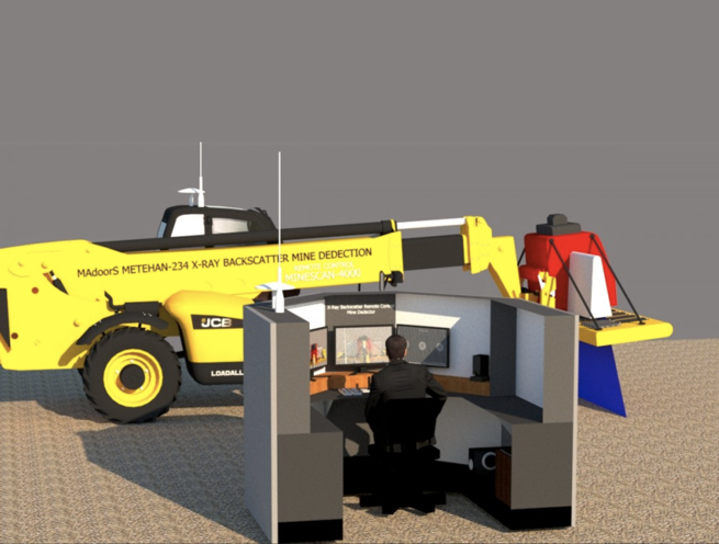
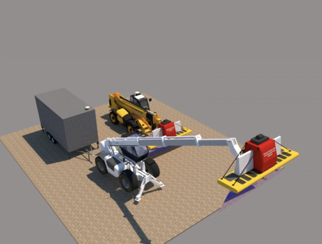
The Madoors USA Minescan-4000 is a mobile X-ray backscatter landmine and tank mine detection system representing a major technology step forward in mine detection — operating at 220 kV, 450 kV, and 650 kV to deliver direct imaging of buried mines at depths to 50 cm across all soil conditions, vegetation types, and mine construction materials including metal-free plastic and composite landmines that conventional metal detector systems cannot detect. Integrated with the remote-controlled armored Metahan-234 mine search vehicle, wireless image transfer to a trailer-mounted control center with dedicated software, satellite-connected automatic mine coordinate mapping, and robotic mine removal capability without human element, the Minescan-4000 system prevents both vehicle and personnel casualties — pinpointing and removing tank mines without detonation, returning mined agricultural land to productive use, and scanning 4 acres of territory per hour with automatic mine mapping and GPS coordinate recording.
TECHNICAL SPECIFICATIONS
The Minescan-4000 X-ray backscatter landmine detection system operates on the fundamental physics principle that the X-ray backscatter signal is directly proportional to the material density of the irradiated volume — allowing direct imaging of buried objects based on their density contrast against the surrounding soil matrix. This density-proportional direct imaging capability is the defining technical advantage of X-ray backscatter technology over all other detection methods — conventional metal detectors, ground-penetrating radar, and acoustic systems provide indirect indicators of buried object presence rather than direct visual images of the object geometry and position.
Voltage options of 220 kV, 450 kV, and 650 kV provide different X-ray energy levels for different soil conditions, burial depths, and detection requirements — with higher voltage providing greater penetration depth and improved image quality in high-density or wet soil conditions that attenuate lower-energy X-ray beams. Detection depth is 50 cm — sufficient to detect all regularly placed mines at the burial depths used in standard military mine-laying practice.
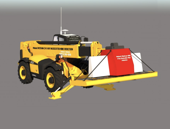
The detection system arm extends 10 meters from the Metahan-234 armored vehicle — allowing the X-ray scanner to reach across the full scan width without the vehicle entering the minefield. Scan width is 2 meters per pass with no length limit per scan run — providing the continuous area coverage required for systematic minefield clearance operations. Scanning speed achieves 4 acres per hour with automatic mine map production — providing the highest available productivity for large-area minefield survey and clearance operations.
The system incorporates two separate computers — one in the remote-controlled armored Metahan-234 mine search vehicle and one in the trailer control center — communicating wirelessly. With satellite connection, there is no distance limit between the operator control position and the scanning vehicle — allowing the system to be controlled from any specified safe distance. Without satellite connection, direct wireless link maintains communication over standard operational distances.
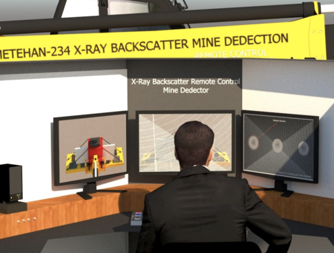
The domestic and nationally developed software automatically detects mines in the X-ray images, marks each mine position, and transmits audio and visual alerts to the remote operator control point. When satellite connection is established, the software automatically generates a mine map — recording each mine's GPS coordinates together with the X-ray photograph, date, and time in a complete data package for each detected mine. This integrated data package provides the documentation required for systematic minefield marking, hazard reporting, and post-clearance verification.
KEY FEATURES
Direct Imaging — Unique Advantage Over All Other Detection Methods
The most important technical argument for the Minescan-4000 is that it is a direct imaging technique — the X-ray backscatter signal forms a visual image of the buried object that a trained operator can identify immediately from the image display. All other mine detection methods — metal detectors, ground-penetrating radar, infrared, and acoustic systems — produce indirect signals that require interpretation and are highly susceptible to false alarms from soil inhomogeneities, metallic debris, and environmental noise. The Minescan-4000 direct image allows the operator to see the mine — its shape, size, and position — rather than inferring its presence from an indirect signal anomaly.
Metal-Free Landmine Detection
The Minescan-4000 detects metal-free landmines — plastic case, composite, and minimum-metal mines that contain no ferrous or metallic components detectable by conventional metal detectors. Metal-free mines represent a critical detection challenge for all conventional detection technologies, and their widespread deployment in conflict zones has rendered metal detector-based demining operations ineffective for comprehensive minefield clearance. The density-proportional X-ray backscatter imaging detects any material with density contrast against the surrounding soil — regardless of whether that material is metallic, plastic, or composite.
All Soil Conditions & Vegetation Types
The Minescan-4000 detects mines buried in all soil conditions — clay, sand, loam, gravel, and mixed soil types — and under various types of vegetation. Soil condition variation is the primary source of false alarms and missed detections in alternative detection technologies. The X-ray backscatter approach is less sensitive to soil condition variation than electromagnetic methods because it responds to material density contrast rather than electrical or magnetic soil properties.
Low False Alarm Rate — High Detection Probability
The direct imaging capability and density-proportional signal provide the potential for significantly lower false alarm rates than conventional detection methods — a trained operator viewing a high-resolution image of a buried object can distinguish a mine from a stone or soil inhomogeneity based on the visual characteristics of the image far more reliably than an operator interpreting an indirect detector signal threshold. Lower false alarm rates directly increase the clearance rate efficiency — reducing the time spent investigating false alarms that dominate conventional demining operations.
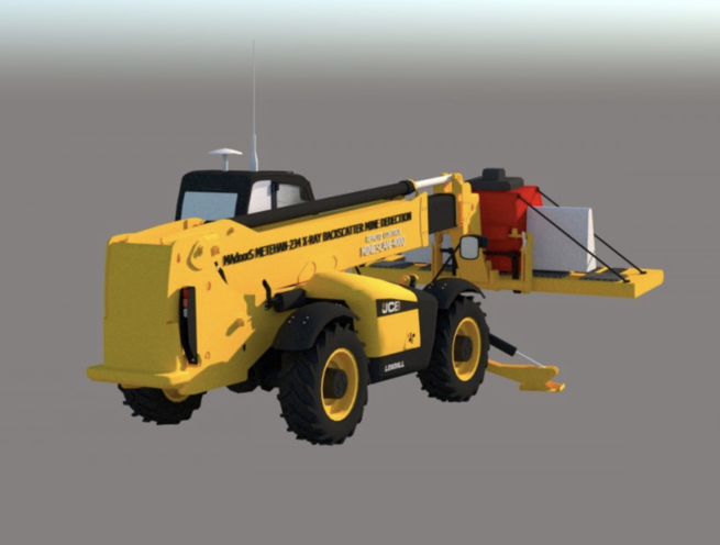
10-Meter Arm Extension — Vehicle Remains Outside Minefield
The 10-meter arm extension between the armored vehicle and the X-ray scanner head allows the Metahan-234 vehicle to remain outside the minefield boundary while the scanner reaches across the full detection width into the mined area. This standoff detection capability directly eliminates the vehicle and crew risk from mine detonation under the vehicle — the vehicle never crosses into the mined area during scanning operations.
4 Acres Per Hour — Automatic Mine Map Production
The 4 acres per hour scanning rate with automatic mine map production from satellite-connected GPS coordinate recording provides a systematic, documented minefield survey capability at rates significantly exceeding manual demining operations. The automatic mine map eliminates the manual marking and recording errors of conventional demining operations and provides a digital data product suitable for hazard reporting, mine action coordination, and post-clearance verification documentation.
Satellite GPS Coordinate Recording — Complete Mine Data Package
Each detected mine is recorded as a complete data package — GPS coordinates, X-ray image photograph, date, and time — automatically compiled by the software in the trailer control computer. This complete data package provides the documentation standard required by international mine action authorities for verified minefield survey records, and the coordinate precision required for subsequent mine removal operations.
Robotic Mine Removal — No Human Element
The robots that clear mines from the ground remove each mine without the human element — eliminating the primary demining casualty risk of manual mine removal by trained deminers working at close range to live mines. Combined with the non-detonating removal capability, robotic mine removal returns the mine intact from the ground for safe disposal — rather than in-place detonation that leaves soil contamination and crater damage. Agricultural land is returned to productive use without the long-term soil damage of in-place detonation.
Non-Detonating Tank Mine Removal — Vehicle & Equipment Protection
Tank mines — pressure-activated anti-vehicle mines designed to defeat armored vehicles by detonating under their running gear — are pinpointed by the Minescan-4000 and removed without detonation. This prevents the equipment damage and loss that affects conventional mine-clearing vehicles using roller and flail systems where tank mine detonation progressively disables the clearing equipment. Both life and property losses are prevented — the Minescan-4000 locates the mine before any vehicle crosses it, and the robotic removal system extracts it without triggering the pressure fuze.
Agricultural Land Recovery
Mines removed without detonation leave the soil undamaged — the mine is extracted intact, leaving a small excavation that is readily rehabilitated for agricultural use. This contrasts with in-place detonation clearance where crater damage, soil compaction, and residual contamination from explosive decomposition reduce the agricultural quality of the cleared land for years after clearance. The Minescan-4000 system thus directly contributes to the humanitarian objective of restoring mined agricultural land to productive use and returning displaced farming communities to their land.
Domestic & National Software Development
The software is completely domestically and nationally developed — with full ownership of the source code, algorithm design, and system architecture. Domestic software ownership ensures supply chain security for military and security procurement, eliminates foreign technology dependency in critical demining operations, and provides the upgrade and modification capability required to adapt the system to new mine types and detection scenarios as they emerge.
SYSTEM ARCHITECTURE
Minescan-4000 X-Ray Scanner Unit — Mounted on 10-meter arm of the Metahan-234 armored vehicle. Emits X-ray beam at selected voltage — 220 kV, 450 kV, or 650 kV. Detects backscattered X-ray signal on sensor array. Generates high-resolution density image of irradiated soil volume.
Metahan-234 Remote-Controlled Armored Mine Search Vehicle — Carries the X-ray scanner arm and the vehicle-mounted computer. Remotely operated — no crew required in the vehicle during scanning operations. Communicates wirelessly with the trailer control center.
Vehicle-Mounted Computer — Receives and processes X-ray sensor data. Communicates with the trailer computer via wireless link. Operates independently or in satellite-connected mode.
Trailer Control Center — Houses the operator control computer, monitors, and imaging software. Receives wirelessly transmitted X-ray images from the vehicle. Operator workstation for mine identification and clearance management.
Mine Detection & Mapping Software — Automatically detects mines in X-ray images. Marks detected mines on the display. Generates GPS coordinate mine map when satellite is connected. Records complete data package — X-ray image, GPS coordinates, date, and time — for each detected mine.
Robotic Mine Removal Units — Remove detected mines from the ground without human element and without detonation.
OPERATIONAL SEQUENCE
Pre-Deployment Setup
Vehicle and trailer are positioned at the minefield perimeter. Satellite connection is established for GPS coordinate mine mapping. Software is initialized with the minefield survey area parameters.
Remote Vehicle Operation
The Metahan-234 is remotely operated from a safe distance — entering the scan lane with the 10-meter arm extended to position the X-ray scanner over the scan path.
X-Ray Scanning
The scanner emits the selected voltage X-ray beam and collects the backscattered signal from the soil volume. High-resolution density images are generated for each 2-meter-wide scan strip at continuous scanning speed.
Wireless Image Transfer & Automatic Detection
Images are transmitted wirelessly to the trailer control center. Software automatically detects mines in the images and marks each detection. Audio and visual alerts are transmitted to the operator.
Mine Map Generation
GPS coordinates of each detected mine are recorded with the X-ray image, date, and time as a complete data package. The mine map is automatically updated with each new detection.
Robotic Mine Removal
Detected mines are removed by robotic clearing units without human element and without detonation. Removed mines are relocated to a safe disposal area.
Cleared Land Return to Agriculture
Cleared mined land — with mines removed without in-place detonation — is rehabilitated and returned to agricultural productive use.
DEPLOYMENT SCENARIOS & USE CASES
Madoors USA Minescan-4000 X-Ray Backscatter Landmine Detection Systems are deployed across the full range of military and humanitarian demining operations.
- Post-conflict agricultural land minefield survey and clearance
- Military forward area route clearance and mine mapping
- Border zone minefield survey and humanitarian clearance
- Anti-vehicle tank mine detection on military approach routes
- Metal-free plastic landmine detection in cleared zone verification
- National demining program systematic minefield survey
- UN and international mine action authority demining operations
- Airport and critical infrastructure perimeter minefield clearance
- Post-conflict urban area mine survey and clearance
- Military training area accidental mine contamination survey
- Humanitarian demining in former conflict zone agricultural areas
- Border region irregular mine contamination survey
- Military engineer route proving and mine marking operations
- Emergency vehicle route clearance in mine-contaminated areas
- Post-disaster mine displacement survey in flood and landslide zones