Backscatter X-Ray Detection of Buried Mine, Landmine Detector
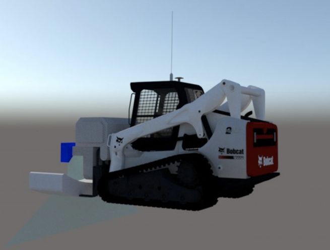
The Madoors USA MineScan-1000 is a patented, domestically designed and manufactured backscatter X-ray buried mine detection system engineered to detect, image, photograph, and record all buried mine types — from the smallest anti-personnel landmine and heel mine through to full-sized anti-tank mines — with real-time audible and visual alerts and automatic red-circle marking of detected mines on the display image. Operating on dual X-ray tube backscatter technology with angled sensor arrays, the MineScan-1000 obtains high-resolution underground images 2.5 meters wide from a 1.5-meter sensor array, providing exceptional coverage in narrow path and walking track environments where conventional mine detection systems cannot operate effectively.
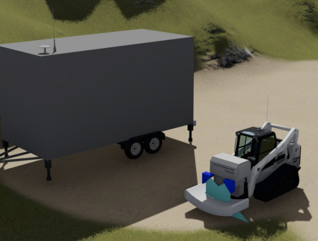
The MineScan-1000 is operated by remote control or with a normal driver, with an optional armored vehicle configuration available from Madoors USA. The imaging and computer system operates from a separate mobile caravan command station, with wireless image transmission to the caravan viewing station and optional Wi-Fi laptop monitoring from inside the driver vehicle during manual operation. All software is domestically developed with national capital by USA engineers. The system is patented, with patent applications filed in February 2020, and is open to new custom designs for project-specific requirements.
TECHNICAL SPECIFICATIONS
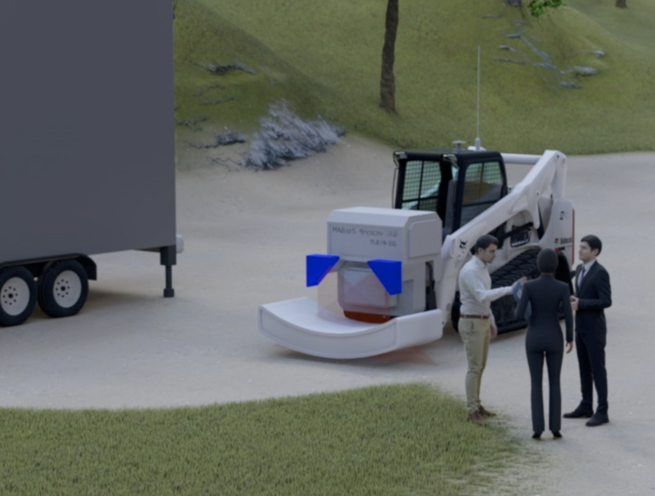
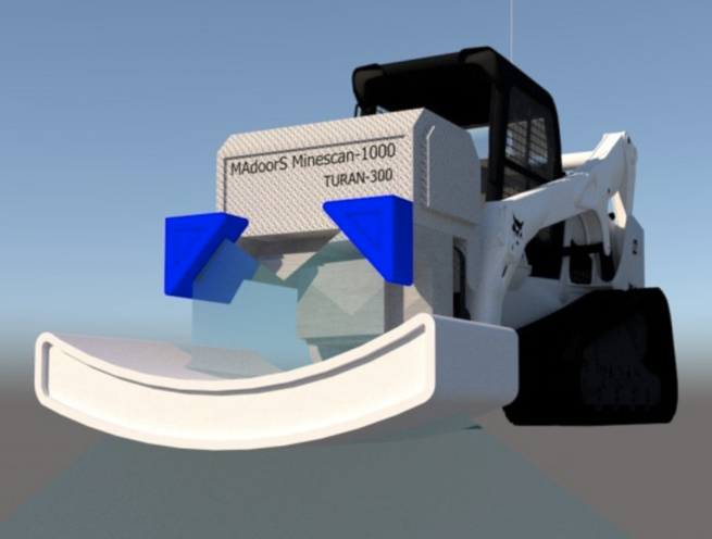
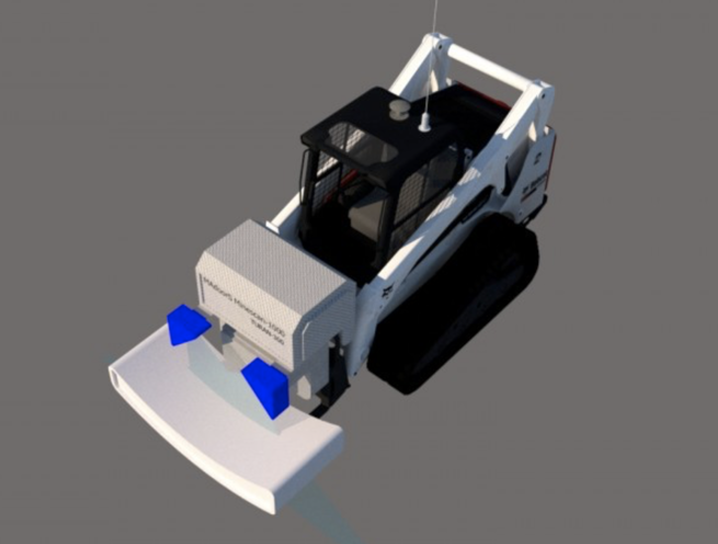
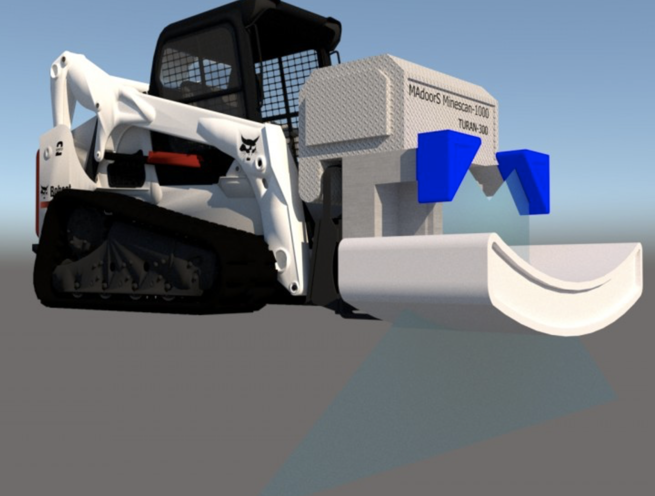
The MineScan-1000 operates on backscatter X-ray detection technology. Two X-ray tubes simultaneously emit X-rays into the ground directly below the scanning vehicle. The X-rays interact with subsurface objects — including buried mines of all types — and the backscattered X-rays returning from the ground are captured by sensor arrays arranged at angles specifically optimized for narrow-space operation. This angled sensor array geometry is the key design advantage of the MineScan-1000 — when the reflected rays from both X-ray tubes fall simultaneously on the angled sensors, the system generates a subsurface image 2.5 meters wide from a sensor array only 1.5 meters in physical width, providing substantially wider underground coverage than the physical sensor footprint would suggest.
The dual X-ray tube and dual power supply configuration provides simultaneous wide-angle dispersion scanning of the ground, generating large, high-resolution images of narrow underground areas in a single pass without requiring multiple overlapping scan runs. The result is a very clear, wide subsurface image that reveals buried mine objects of all sizes in detail.
Detected mines are immediately flagged with an audible warning and a visual alert, and automatically marked with a red circle on the display image for unambiguous identification by the operator. All detection images are photographed and recorded for documentation, reporting, and post-operation mine mapping purposes.
The computer and imaging system software operates from a dedicated mobile caravan command station. During remote-controlled vehicle operation, the system is monitored from the caravan viewing station via wireless connection. During manual driver operation, the system can alternatively be monitored from inside the driver vehicle via Wi-Fi connection to a portable laptop computer. All system software is domestically developed national software.
KEY FEATURES
Backscatter X-Ray Detection — All Mine Types
The MineScan-1000 detects all buried mine types through backscatter X-ray imaging — including the smallest anti-personnel landmines, heel mines, and full-sized anti-tank mines. Backscatter X-ray technology provides subsurface imaging capability that is independent of mine material composition — detecting plastic-bodied mines that defeat metal detector-based systems as effectively as metal-cased mines.
Dual X-Ray Tube Simultaneous Scanning
Two X-ray tubes operate simultaneously, each emitting X-rays into the ground at the same time and with wide-angle dispersion. The dual simultaneous emission provides the broad underground coverage required for reliable mine detection across the full width of a narrow path or track in a single pass — without the coverage gaps that single-tube scanning systems present at the edges of the sensor footprint.
2.5-Meter Image Width from 1.5-Meter Sensor Array
The angled sensor array geometry generates a subsurface image 2.5 meters wide from a physical sensor array only 1.5 meters wide — providing 67% more underground coverage than the physical array width, a direct result of the dual-tube angled sensor design. This extended coverage width is the defining performance characteristic of the MineScan-1000 for narrow path and track clearance operations where the vehicle width constrains the physical sensor array size.
Angled Sensor Array — Narrow Space Optimized
The sensor arrays are arranged at angles specifically calculated for narrow-space operation, ensuring that the backscattered X-rays from both tubes fall on the sensor surfaces at the optimal angle for maximum signal capture and image resolution in the confined geometry of narrow walking paths, mountain trails, and track-width mine clearance operations.
Automatic Red-Circle Mine Marking
Detected mines are automatically marked with a red circle on the display image at the moment of detection, providing immediate, unambiguous visual identification of the mine location within the subsurface image without requiring operator interpretation of subtle image anomalies. Red-circle automatic marking directly reduces the operator workload and mine identification error rate during active scanning operations.
Immediate Audible & Visual Alert
The MineScan-1000 generates an immediate audible warning and visual alert as soon as a mine is detected, ensuring that the operator and associated personnel are immediately notified of a detection event without delay — a critical response time requirement for mine detection systems operating in active threat environments.
Photo Capture & Digital Recording All mine detections are photographed and digitally recorded, creating a complete documented record of mine locations, image evidence of each detected object, and a mine mapping dataset for post-clearance reporting, route marking, and operational debrief. Digital recording supports systematic mine clearance operations where all detected mines must be documented before neutralization teams are deployed.
Remote Control & Normal Driver Operation
The MineScan-1000 supports both remote-controlled vehicle operation — allowing the detector vehicle to be operated from a safe standoff distance via wireless remote control — and normal driver operation for environments where remote control is impractical or unnecessary. Remote control operation protects the driver from mine detonation risk during scanning of actively mined areas, while driver operation provides more flexible navigation in complex terrain.
Optional Armored Vehicle Configuration
The vehicle carrying the MineScan-1000 detector can be optionally armored by Madoors USA, providing the vehicle crew and equipment with protection against mine detonation, small arms fire, and fragmentation during scanning operations in active threat environments — converting the detector vehicle into a protected platform for higher-risk clearance operations.
Mobile Caravan Command Station
The computer and imaging system software operates from a dedicated separate mobile caravan, providing a protected, environmentally controlled command and display station for the system operator independent of the detector vehicle. The mobile caravan can be positioned at a safe standoff distance from the active scanning area during remote-controlled operation.
Wi-Fi Laptop Monitoring — Driver Vehicle
During manual driver operation, the MineScan-1000 can be monitored from inside the driver vehicle via Wi-Fi connection to a portable laptop computer — providing the driver operator with real-time subsurface image display and mine alert notification without requiring a separate monitoring station vehicle in the convoy.
Wireless Image Transmission
All subsurface images are transmitted wirelessly from the detector vehicle to the caravan imaging station and the Wi-Fi laptop display, eliminating cable connections between the moving detector vehicle and the command station and providing reliable image transmission across the operational range of the wireless system.
ASSEMBLY & OPERATIONAL DEPLOYMENT SEQUENCE
Mission Planning & Route Assessment
The target clearance route — path width, terrain type, anticipated mine types, and threat level — is assessed. Vehicle configuration — remote-controlled or driver-operated, standard or armored — is confirmed. Mobile caravan command station deployment position is planned relative to the scanning route and safe standoff distance requirements.
System Assembly & Vehicle Integration
The MineScan-1000 sensor array, dual X-ray tubes, dual power supplies, and angled sensor mounting are assembled on the detector vehicle. All system connections are verified. The mobile caravan command station is positioned and the computer and imaging software system is initialized.
Wireless Communication Establishment
Wireless communication between the detector vehicle and the mobile caravan command station is established and verified. For driver-operated configurations, Wi-Fi connection to the portable laptop in the driver vehicle is established. Image transmission from the detector system to the display station is tested and verified.
Calibration & Pre-Scan System Check
The dual X-ray tube system is calibrated for the soil type and ground conditions of the specific clearance route. Sensor array angle and image width are verified. Alert thresholds for audible and visual mine detection notifications are confirmed. Red-circle marking and photo recording functions are tested.
Active Scanning — Route Clearance Pass
The detector vehicle proceeds along the clearance route at the specified scanning speed. The dual X-ray tubes emit simultaneously into the ground, generating real-time subsurface images transmitted wirelessly to the command station display. Detected mines trigger immediate audible and visual alerts and automatic red-circle marking on the displayed image. All detections are photographed and recorded automatically.
Mine Location Documentation & Marking
All detected mine locations are documented from the recorded images and GPS position data. Physical surface marking of detected mine locations is completed by clearance team personnel following the scanning pass, using the recorded image data to confirm mine positions for neutralization team deployment.
Post-Scan Reporting
Recorded detection images, mine location data, and route clearance documentation are compiled into a post-scan report for operational command, mine clearance coordination, and route opening authorization.
DEPLOYMENT SCENARIOS & USE CASES
Madoors USA MineScan-1000 Backscatter X-Ray Landmine Detectors are deployed across the full range of military, humanitarian, and infrastructure mine clearance operations.
- Military route clearance operations in active conflict zones
- Post-conflict humanitarian mine clearance programs
- Narrow path and mountain trail mine detection operations
- Border security mine clearance along frontier zones
- Road and transport route opening after conflict
- Agricultural land mine clearance for civilian return programs
- Infrastructure reconstruction mine clearance — power lines, pipelines
- Military exercise area mine and UXO detection
- EOD route clearance support operations
- United Nations and NGO humanitarian demining operations
- Critical infrastructure approach route mine clearance
- Airport and airfield perimeter mine detection operations
- Military base perimeter and approach route clearance
- Post-conflict urban area mine and IED detection support